
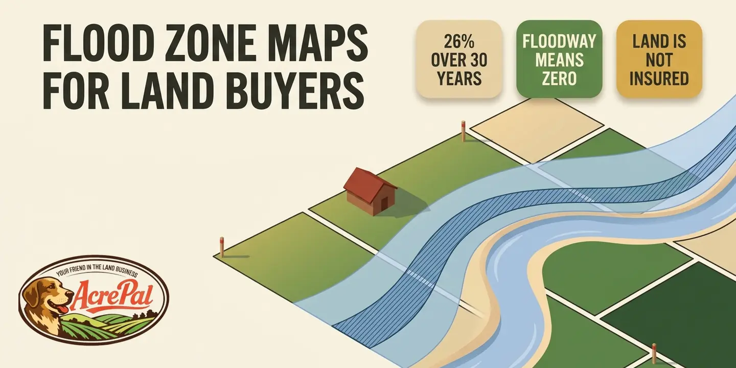
Two parcels can come back Zone AE on the same map, on the same river, a quarter mile apart, and one of them can be built on while the other one cannot. The difference is not the letter. It is a hatched overlay printed on top of the letter, and most guides on this subject never mention it.
A flood zone map is FEMA's official picture of which land carries which flood risk. It is published as a Flood Insurance Rate Map, and it is what lenders, insurers, and the county office that issues building permits all read from.
Most flood zone guides are written for somebody buying a house, so they organize around what the insurance will cost. If there is no house yet, the premium is a question you cannot ask. The question you can ask is whether the county will ever let you put a structure there.
We read the federal floodplain rules in 44 CFR and quote them below with section numbers so you can check every one. We also queried FEMA's own National Flood Hazard Layer at real coordinates in all six counties where we sell land, and printed what came back, including the three results a buyer would not expect.
How to Look Up a Parcel on the FEMA Flood Zone Map
FEMA's lookup tool wants a street address. Raw land usually does not have one. You get around it by starting from the parcel number and working in coordinates.
Finding the Parcel When There Is No Street Address
- Start from the APN, not an address. Pull the parcel on your county assessor's GIS and read the latitude and longitude off the centroid. Some counties save you the trouble, and Mohave County's Arizona flood viewer searches by parcel number.
- Search FEMA's Flood Map Service Center at msc.fema.gov. With coordinates rather than an address, use the map view and navigate to the point.
- Open the National Flood Hazard Layer viewer. A downloaded map panel is a picture. The Layer is the live data behind it, and the only way to see a zone boundary against a parcel boundary.
- Zoom to see whether a boundary crosses the parcel. A parcel can be half in and half out, and the half it is in governs where a structure can go. Reading topographic maps covers the contours underneath.
- Then call the county floodplain administrator. The county issues the permit, FEMA does not, and that call matters more than anything printed on the map.
Reading What Comes Back
Five things can come back. V and VE are coastal zones an inland parcel will not see.
| What the map shows | What it means for a vacant parcel |
|---|---|
| Zone A | One percent annual chance, no base flood elevation, because no detailed study was funded. The hardest case, since there is no published number to build above. |
| Zone AE | One percent annual chance with a published base flood elevation, so you know the number to clear. |
| Zone X | Outside the one percent annual chance area. Shaded X sits between the one percent and the 0.2 percent chance. Lower risk, not no risk. |
| Zone D | No flood hazard analysis has been done. That says nobody looked, not that you are fine. |
| The hatched overlay | The regulatory floodway, drawn inside Zones A and AE. This decides whether you can build at all. |
Zone X gets called a non-flood zone. The NFIP reports that "From 2014 - 2024, nearly one-third of NFIP claims came from outside high-risk flood areas."
Under 44 CFR 59.1, "Base flood means the flood having a one percent chance of being equalled or exceeded in any given year."
Read the letter first, then look for the hatching.
Inside the Floodway, the Standard Is Zero
Across the six pages ranking for this subject that we measured, the word floodway does not appear once. It decides whether a vacant parcel can be built on.
44 CFR 59.1 defines it. "Regulatory floodway means the channel of a river or other watercourse and the adjacent land areas that must be reserved in order to discharge the base flood without cumulatively increasing the water surface elevation more than a designated height." The water needs that space, and the community must keep it clear.
Under 44 CFR 60.3(d)(3), a participating community has to "Prohibit encroachments, including fill, new construction, substantial improvements, and other development within the adopted regulatory floodway unless it has been demonstrated through hydrologic and hydraulic analyses performed in accordance with standard engineering practice that the proposed encroachment would not result in any increase in flood levels within the community during the occurrence of the base flood discharge".
Any increase. Not a tolerable one. Zero.
Fill is named first in that list, ahead of new construction, which forecloses the intuitive fix.
You may half remember a one foot rule. It is real, and it lives elsewhere. 44 CFR 60.3(d)(2) requires a community to "Select and adopt a regulatory floodway based on the principle that the area chosen for the regulatory floodway must be designed to carry the waters of the base flood, without increasing the water surface elevation of that flood more than one foot at any point".
The one foot governs how the community draws the floodway. The zero governs what you may build in it. Two numbers, two jobs.
Not every AE zone has an adopted floodway, so ask the floodplain administrator whether one exists on your stretch. Until one is designated, 44 CFR 60.3(c)(10) applies a one foot cumulative limit instead.
The standard escape plan is fill. Truck in dirt, raise the ground, change the map. 44 CFR 72.2 defines it. "LOMR-F. A LOMR-F is FEMA's modification of the SFHA shown on the FIRM based on the placement of fill outside the existing regulatory floodway."
Fill is prohibited inside the floodway, and the remedy it would buy is defined only for fill placed outside. A closed loop.
It is not an absolute bar. Under 44 CFR 60.3(d)(4) a community may permit an encroachment that raises base flood elevations, but only through a conditional FIRM and floodway revision under section 65.12 that the community itself applies for. Nobody runs that process for one five acre lot.
If the hatching crosses the buildable part of the parcel, treat the price as the price of land you will not build on.
What Counts as Development, and Why It Starts Before You Build
You can perform regulated development on a floodplain parcel without building anything. That comes down to how the federal rules define the word.
Under 44 CFR 59.1, "Development means any man-made change to improved or unimproved real estate, including but not limited to buildings or other structures, mining, dredging, filling, grading, paving, excavation or drilling operations or storage of equipment or materials."
Three phrases should stop a land buyer cold. "or unimproved real estate", which is what you own. "grading" and "filling", which is a driveway and a leveled pad. "storage of equipment or materials", which is a shipping container or a parked trailer.
Leveling a spot for a camper is development. The permit is a floodplain development permit, not a building permit, and one does not get you the other. Landmodo is the only page here that names it separately.
No FEMA flood zone map does not mean no county rule. Modoc County, California, one of our six, requires a development permit before any construction in an area of special flood hazard, and its ordinance reaches all proposed construction even where FEMA has not mapped one. 44 CFR 60.3(a)(4) requires communities to review new development for whether it will be reasonably safe from flooding.
Whether an RV Is Treated Differently From a Mobile Home
44 CFR 59.1 says "Structure means, for floodplain management purposes, a walled and roofed building, including a gas or liquid storage tank, that is principally above ground, as well as a manufactured home." A mobile home is a regulated structure. The manufactured home definition ends with a carve out, "The term 'manufactured home' does not include a 'recreational vehicle'."
An RV must pass all four tests. Built on a single chassis, 400 square feet or less at the largest horizontal projection, self-propelled or permanently towable by a light duty truck, and designed as temporary living quarters rather than a permanent dwelling. Local ordinances add their own limits on how long an RV may stay and whether it may connect to utilities.
A floodplain overlay sits on top of base zoning, so a use rural residential zoning allows can still be stopped by the floodplain ordinance.
What the Flood Maps Show in the Six Counties We Sell In
On August 3, 2026 we queried the National Flood Hazard Layer at seven real coordinates across our six counties. Three came back with something a buyer would not expect.
| County and area | What the National Flood Hazard Layer returned |
|---|---|
| Putnam County FL, near Palatka | Zone X, area of minimal flood hazard |
| Putnam County FL, Crescent Lake area | Zone X, area of minimal flood hazard |
| Mohave County AZ, Golden Valley | Zone X, area of minimal flood hazard |
| Apache County AZ, near Concho | Zone D |
| Costilla County CO, near San Luis | No mapped feature at that point |
| Elko County NV, near Elko | Zone AE, special flood hazard area |
| Modoc County CA, Alturas | Zone X, area of minimal flood hazard |
Every Zone X point returned the special flood hazard area flag false. Apache County came back Zone D, the undetermined risk designation, which says nobody has studied it, not that the buyer is safe.
Costilla County returned no mapped feature at the point we queried. A wider box over the county did return features, so it is thinly mapped rather than blank. Costilla's own materials describe a floodplain district and a land use permit process, so local rules exist regardless.
Elko County returned Zone AE with the special flood hazard area flag set, in the Humboldt River corridor, a genuine one percent annual chance area with published base flood elevations in a county people assume is desert.
Across the six pages we measured, not one names a single state, county, or local ordinance. Flood rules are administered locally.
These are single points near county seats and known drainages, capped samples rather than county totals or parcel level determinations. Check every parcel on its own coordinates.
The Well and Septic Trap on Floodplain Land
On a rural parcel the well and the septic system are usually the biggest checks the owner writes before a house exists. In a flood-prone area federal rules dictate how both must be built, and the federal flood policy will not cover either one.
44 CFR 60.3(a)(5) and (a)(6) direct communities to "(5) Require within flood-prone areas new and replacement water supply systems to be designed to minimize or eliminate infiltration of flood waters into the systems; and (6) Require within flood-prone areas (i) new and replacement sanitary sewage systems to be designed to minimize or eliminate infiltration of flood waters into the systems and discharges from the systems into flood waters and (ii) onsite waste disposal systems to be located to avoid impairment to them or contamination from them during flooding."
Both requirements apply "within flood-prone areas", and 44 CFR 59.1 defines flood plain or flood-prone area as "any land area susceptible to being inundated by water from any source". That is broader than a mapped special flood hazard area, which means these requirements can reach a parcel the flood zone map never shaded.
The Standard Flood Insurance Policy, published at 44 CFR Part 61 Appendix A(1), lists what it will not cover. Section IV, Property Not Insured, opens "We do not insure any of the following". Item 8 on that list reads "Underground structures and equipment, including wells, septic tanks, and septic systems." The policy contract names them in its own exclusion list, so the gap is deliberate.
Federal rules tell you how to build a well and a septic system so they survive a flood. The federal flood policy then declines to insure either one. Both of those come from Title 44 of the Code of Federal Regulations.
The numbers live elsewhere. Our breakdowns of well and septic cost and what a perc test costs cover what you should expect to spend. Before you buy, ask the county environmental health office whether a system can be permitted on that specific parcel, and price the answer in.
What a Flood Zone Costs You Over a Thirty Year Hold
A one percent annual chance is not a one percent problem. Over thirty years it compounds to 26.03 percent.
Floodsmart.gov, the NFIP's own site, states that "Due to the changes in the NFIP's pricing approach, flood zones and the structure's elevation relative to Base Flood Elevation (BFE) - as depicted on flood maps - are no longer the only factors utilized in setting flood insurance premiums." The letter does not set the price.
It still sets the obligation. In a high risk zone, a federally backed mortgage makes flood insurance a condition of the loan. Price and requirement are two separate questions, and the zone letter now answers only the second. Owner financed buyers often have no such lender, which removes the requirement without removing any of the risk.
What a policy covers matters more. The Standard Flood Insurance Policy's Property Not Insured section excludes "Land, land values, lawns, trees, shrubs, plants, growing crops, or animals." Landmodo is the only page here that tells a reader raw vacant land cannot be insured. Hold it in a high risk zone and you carry that exposure personally, at any price.
Coverage also has two ceilings, not one. A single family dwelling can carry $250,000 in the Regular Program but only $35,000 in the Emergency Program, where communities skew small and rural.
The Arithmetic, Which Is the Only Exact Number Here
| Hold period | Cumulative chance of at least one base flood |
|---|---|
| 5 years | 4.90% |
| 10 years | 9.56% |
| 15 years | 13.99% |
| 30 years | 26.03% |
| 50 years | 39.50% |
The formula is 1 minus 0.99 to the power of the years. In the 0.2 percent annual chance area, thirty years works out to 5.83 percent.
The Worked Example
The flood math is its own line item, separate from the monthly payment our land loan calculator covers.
- Zone AE, a planned structure worth $150,000, lowest floor at the base flood elevation with no freeboard, held thirty years.
- Cumulative chance of at least one base flood over that hold, 26.03 percent.
- Premium at a placeholder rate of $1,200 a year, held thirty years, comes to $36,000. The $1,200 is a placeholder, not a quote and not an average.
- At half and one and a half times that rate, the thirty year total lands between $18,000 and $54,000.
- So $36,000 of premium is roughly a quarter of the $150,000 structure it protects, against a 26.03 percent chance of one base flood.
- None of that covers the land, the well, or the septic system, and in an Emergency Program community the $150,000 is not available at any price.
The calculator below runs that math on your own inputs. The probability output is exact arithmetic. The premium output is a rough estimate you should replace with a real quote.
Flood Risk Cost Estimator
Read your zone off the flood map, then set the numbers to your own parcel. The probability is exact arithmetic. The premium is a rough placeholder you should replace with a real quote.
Chance of at least one base flood while you own it
26.03%
a 1 percent annual chance compounded over 30 years, about 1 in 3.8
WHAT THAT SETUP RULES IN OR OUT
The probability figures are plain compound arithmetic, 1 minus 0.99 raised to the number of years for a 1 percent annual chance area, and they describe the parcel rather than any particular building. The premium figure is only the number you typed multiplied by the years, and it is not a quote. FEMA no longer prices flood insurance on the zone letter alone, so get a real quote before you rely on any of this. None of this money covers the land itself, the well, or the septic system, all of which the standard policy excludes. Zone D means no flood study has been done, not that the risk is low.
How to Get a Parcel Taken Off the Flood Map
If the map is wrong about your parcel, there are two fixes, and the cheaper one is free. This covers parcels outside the floodway.
Door one is the Letter of Map Amendment, for a parcel whose natural ground was always above the base flood elevation and where no fill was placed. FEMA charges nothing. 44 CFR 72.5 states that "Requesters are exempt from submitting review and processing fees for: ... (c) Requests for a Letter of Map Amendment (LOMA)".
Door two is the Letter of Map Revision Based on Fill, for a parcel raised above the base flood elevation with fill. 44 CFR 72.1 names LOMR-Fs among the products carrying engineering review and processing fees, and 44 CFR 72.3 makes them flat user fees set by separate notice rather than printed in the regulation. FEMA's most recent published schedule, effective February 20, 2015, puts a single lot LOMR-F at $525, or $425 filed online. That is still the newest figure in the Federal Register, so confirm it with FEMA before you budget. A LOMR-F covers fill placed outside the existing regulatory floodway, so inside the floodway this door is not expensive, it is closed.
Expect it to be slow. One owner describes months rather than days even when FEMA has clearly mapped the property wrong. Another calls it agonizingly slow and painful but still the only option. Those are characterizations from people who have filed, not FEMA processing times.
Do not buy a parcel on the assumption you will win a map change. A LOMA requires the ground to already sit above the base flood elevation, and proving that takes a licensed surveyor and an elevation certificate before FEMA looks at anything, which is what a land survey is for. A map change also changes only what the map says, so ask the floodplain administrator what it changes about the permit.
Frequently Asked Questions About Flood Zone Maps
Can you build in a floodway?
Almost never. Federal minimum standards at 44 CFR 60.3(d)(3) prohibit encroachments including fill and new construction inside an adopted regulatory floodway unless engineering analyses demonstrate no increase in flood levels at all. The one exception is not yours to use, because a community, not an individual owner, applies to FEMA for a conditional floodway revision.
What do I do if my parcel comes back unmapped on the FEMA flood map?
Treat it as undetermined risk, because unmapped means nobody studied it, not that it is safe. Call the county floodplain administrator first, since many counties require a development permit whether or not FEMA has drawn a special flood hazard area. Then check the parcel's elevation against the nearest drainage.
Can you insure vacant land against flooding?
No. The Standard Flood Insurance Policy expressly excludes "Land, land values, lawns, trees, shrubs, plants, growing crops, or animals", and there is no NFIP product for a bare parcel. Coverage becomes available once a structure exists, and even then it does not extend to the well or the septic system.
Does a LOMA cost anything?
FEMA charges no review or processing fee for a Letter of Map Amendment, and 44 CFR 72.5 exempts LOMA requests by name. The costs are yours, mainly a licensed surveyor and an elevation certificate. A Letter of Map Revision Based on Fill is a different product and does carry a FEMA processing fee.
Does Zone X mean the land will not flood?
No. Zone X means the parcel sits outside the one percent annual chance area, not that water cannot reach it. The NFIP reports that from 2014 to 2024, nearly one-third of NFIP claims came from outside high-risk flood areas. Shaded X sits between the one percent and the 0.2 percent annual chance.
Can you put an RV on land in a flood zone?
Under 44 CFR 59.1, a recreational vehicle meeting all four federal tests is not a manufactured home and is not treated as a structure, while a mobile home is. That is only the federal half. Local ordinances add limits on how long an RV may stay and whether it may connect to utilities, so ask the county.
How do I look up the flood zone for a property with no street address?
Start from the APN, pull the parcel on the county assessor's GIS to get coordinates, then navigate to that point on FEMA's Flood Map Service Center or in the National Flood Hazard Layer viewer instead of using the address search. Some county flood viewers accept a parcel number directly.